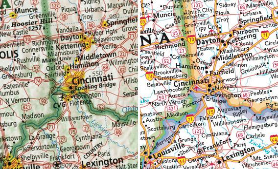
Oldie but a goodie. francopoli reminded me it existed.
And Fox bought NatGeo, so I tipped my hat and waved goodbye
I'm thrilled by this map. I want to order a print for my room, though the product descriptions are a little unclear. I love a good map. Here's one on my wall: This map was commissioned by the Ottoman Empire in 1802. Labeled in Turkish Arabic, the recently formed United States are called “The Country of the English People,” and the pink highlighted lands to the north are the Iroquois Confederacy, labeled the “Government of the Six Indian Nations,” as well as some other Indian tribes. edit to ping: mk -- look! Our mitten is a little misshapen, but undeniably there waving.
Not exactly a map but a useful thing too. On this website https://populationstat.com/united-states/chicago you can find information about American cities population. Age, life expectancy, urbanization level and so on. Quite a useful tool.
From a glance, the NG map looks better: it has more contrast and manages to include all the city/town names without any (significant to an eye) overlap with other features. The auxiliary details don't seem to be a great enough addition to warrant such inclusion of time and effort.
I disagree, because the Imus map provides more detail. Perhaps it would help to view the map itself. Click full screen. The Imus map has information about: 1. The tree density 2. The terrain 3. The population-dense places 4. City features Among other things. The NG map does not have this information. So comparing between two maps of the same size, the Imus map has a much greater amount of information without sacrificing clarity or readability.
The NG map is specifically stated to be political, therefore it doesn't have to have this kind of information. It's not good bashing something for what it's not. Perhaps you're right about the rest, but I don't have it in me to investigate further at the moment.The NG map does not have this information.
The title you gave the map still sounds like an overstatement. It's pretty good. Greatest, though? I, a casual observer, don't see that. The mapmaker talks about "basic geographical awareness", and he has some good points (like the population density one), but I don't see it as being this important. Is there really as big a crisis of mapmaking in the US as the article makes it seem? and is it as important? I don't remember encountering such a problem in Russia or having trouble orientating myself on any given type of map.
If anything it is very well designed and seems to take all the best lessons and practices of cartography into account. What is also good in my opinion about his map over the NG one, besides the decision to not color state borders, is how he managed to keep every city label horizontal, curve-less and rarely overlapping big roads. One can also see that he managed to make all the highways easy to trace and have each highway icon exactly on the highway. That sounds trivial but I speak from experience that just doing labeling properly and consistently can be an enormous task. To have a map that is thought out down to that level of detail for the entire U.S. without having major design flaws is definitely worth something in my book. I agree that 'crisis' is a hyperbole. But the art of cartography has been getting less and less appreciation in the last decade or two. It's been so easy to make an okay map that barely anyone takes the time anymore to craft a great map.
To me this is like saying, "Why did you rebuild this sports car? Normal cars get the job done fine." Or one I've been personally told: "Why install a custom OS on your phone? It worked fine before." You may not see these improvements as important, but to someone with a passion for maps, it may mean a lot. I find that kind of passion for almost anything admirable. This guy hand-built a thing better than can be bought by map companies. That's pretty cool, even if you don't care about maps (I can't say I have a passion for maps, either). I couldn't give less of a shit about cars, in fact I hate them, but if someone custom built a car as a hobby exactly the way they wanted to, I would think that was really cool.
I have a massive physical world map from 20 years ago, back when such things were expensive, made by hand and ridiculous. I haven't put it back up since we moved. I oughtta do that. I mounted the dumb thing; it's over six feet wide and weighs a hundred pounds.
IMO there is something important about having a grasp of the scale and position of features on this globe. It can counter-balance all the social-centric landscapes that we are constantly confronting. I want my daughter to know she is able to walk east and come upon the St. Lawrence Seaway.
I've always wanted to paint a roughly square room with a map of the world... projected from the INSIDE. Like you were standing at the center of a globe, looking out at transparent walls. Above you is the Arctic. Below you is Antarctica. In the middle of the room I'd have a lamp, with a half-silvered bulb, that would rotate 365 degrees every 24 hours, so I could always just walk into the room and see the Terminator line... where the Sun was rising right now... where it was setting... Man... I'd love that room.
