I had a coworker who claimed that we (nations) were only claiming that we didn't have radar of the plane the entire time because it would hurt our diplomatic position to admit that, say, the U.S. was patrolling all airwaves, all the time, tracking all planes. I don't know.
If A Tree Falls In the Woods... So let's take an airliner. Call it an Airbus, and let's say it's flying out of Malaysia. Let's analyze every bit of signal we can get from it, from DC to light and then some: At the low end, which is low power, we've got noise and interference. A little above that we've got shortwave - what it uses to communicate with other airliners and the control tower. In flight, it gives off heat. As it flies about it blinks and announces its presence to anyone looking in its general direction. These are active signals that we can absorb. Big enough antenna, sensitive enough thermal imager, we see it. It will show up on radar if we ping it. An active infrared sensor (like the one that turns on your garage lights) will react to its presence. Obviously, we can see the airplane; it's not invisible. These are passive responses we can instigate. Shine a radar beam at an Airbus and you will see an Airbus. It's noisy, too. If it flies overhead we hear it. Should the weather be right, we'll see its contrail. That's what you get out of an airliner. ...And Nobody Hears It... There's a supposition that we live in a perpetual surveillance state since the NSA is on our phone all the time but this understanding does not take into account the realities of physics or organization. Intelligence is broken up into different disciplines that collect and collate their information differently. - HUMINT (HUMan INTelligence) is what the traitor told you. That's the pilot's buddy saying "he's got a flight simulator at home". This is classic James Bond shit, Mata Hari using her feminine wiles to learn the Nazi invasion plans. - IMINT (IMaging INTelligence) is what you can photograph. Largely done by satellites. Contrary to Hollywood notions, IMINT has more in common with mowing the lawn than the all-seeing eye. Satellite orbits are highly predictable and changing them is very expensive - a KH-11 costs about as much to get into operation as a Nimitz-class aircraft carrier costs to get out of the shipyard and every time you use propellant, you shorten its useful life. While modern electro-optical intelligence satellites provide near-real-time data on whatever they're pointed at, there are a limited number of them, a limited number of relays to get the information to the ground, and a limited number of professionals to analyze that IMINT. In order for useful IMINT of a wayward airliner to exist, that wayward airliner would either have to be under task already or nearly on top of something that already is. As a general rule of thumb, IMINT does not often touch the middle of the deep blue sea unless there happens to be something interesting there. It happens - a CORONA accidentally imaged a Soviet ASAT test in the Arctic back in the early '80s - but the odds are stacked against it. ELINT (ELectronic INTelligence): telemetry and other signals data that does not contain speech or other human elements. This is the engine telemetry talking to BAE, LORAN signals, etc. ELINT is captured by big skookum dishes up in space, by big skookum dishes in curious places (there's a Naval Undersea Warfare Center in Hawthorne, NV, for example - they exist to snoop on Russian ELF sub communication) and by a dragnet of ship and air-based intelligence vehicles. Some of the broad-band stuff gets picked up but by and large, if you want this stuff, you have to seek it out. Say you want the telemetry of a North Korean missile test. You park a flotilla of "fishing trawlers" off the coast of Pyongyang and loft a squadron of AWACS. No flotilla? No trawlers? Not a lot of data for you. COMINT (COMmunications INTelligence): This is control tower conversations, in-flight internet packets, etc. This stuff is much easier to grab at the source - Kuala Lumpur Control streams on the Internet, FFS. Commercial airline traffic isn't encrypted so this stuff is yours for the taking. ...Did It Make A Sound? There are distinct groups that pay attention to some of this stuff and ignore the rest. The NRO cares about anything gathered from space. They'll share that information around with anybody with similar interests on the chain of command. Anything flying over the ocean is the purvey of naval intelligence which has its own satellites. Fishing trawlers are generally CIA/NSA joint operations and AWACS are DIA (Defense Intelligence Agency). The NSA will intercept any signal over the air or over a trunk, be it copper, fiber or cans with string. It all gets shared around on something called A-Space, which is basically Facebook for spooks. Not In My Woods It Doesn't. That's assuming you have spy satellites. Giant skookum radar dishes. Flotillas of trawlers, squadrons of AWACs, Mata Hari listening to pillow talk. We're talking about Malaysia. Who have so far been extremely reluctant to engage the assistance or participation of any other government. Probably because it's going to make them look really, really bad. Look. Malaysia has half as many muslims as Saudi Arabia or Iraq and twice as many as Tajikistan or Kuwait. A lot of them are militant. The plurality of the world's muslims don't live in South Asia, they live in the Pacific Rim... and they're not non-violent. KL, meanwhile, has been trying to show itself as a prominent world power for the past twenty years: the Petronas Towers exist solely to say "Hey world, we're legit." Balance that against a fundamentalist faction that doesn't want women to learn how to read and you have the makings for some real social tension. The Ockham's Razor on the situation is that the government of Malaysia had some embarassing indications that "Bin Laden Determined to Attack Within US" about the pilot and either couldn't get its shit together in time to do something about it or chose not to act because of the potential dust-up of cracking down on a fundamentalist pilot without a really, really good reason. So now they're looking at a no-win situation where the whole world is going to second-guess their every move no matter what they do; if they hand the investigation over to the guys who actually have all the shit listed above they're nothing but a province all over again. Kuala Lumpur, May 1969: Kuala Lumpur, May 2012: Cockups before conspiracy. Somebody somewhere had a pretty strong indication that something bad was going to happen to an airliner and now that it did happen, a whole lot of mud is going to be on a whole lot of faces. By controlling the investigation, Malaysia hopes to make everybody remember the shiny color sunset skyscrapers rather than the dirt roads and black'n'white. It's not a particularly glamorous interpretation, but it's been my experience that behind every grand conspiracy theory there's a tiny, regrettable fuckup that might actually hurt somebody's career if it came to light.


Satellite guy here. I really really enjoyed this analysis. My only point of objection (does anyone dare object to kleinbl00?) is in your assumptions on our current capabilities regarding satellite image resolution. It's likely that we've worked our way far out of the megapixel range, and combined this capability with fish-eye lensing techniques. The general rule is that the information in the public domain is ~15 years outdated behind what's actually being employed on the cutting edge of tech. That interval of time may have shortened somewhat, thanks to the internet. So... you'd only need a few pixels of airplane to be able to track its movements. There's a LOT of surveillance stuff in Low Earth Orbit (LEO), and the way that the above linked declassified resolution (6 inches resolution @ 20,000 ft.) scales should be able to resolve something as large as a 777 in LEO, with a fish-eye lens. Again... the usage of a fish-eye lens is presumed, but likely. Additionally, who says that the field of view of these cameras is limited to staring straight down at the ground? I can assure you that we (the United States) have the ability to select a surveillance satellite and reorient the direction of the onboard sensors in any direction we so desire. Again, this is a question of real-time response to a request, which the Malaysian government probably never had the initiative to initiate on an immediate time scale. Basically, I'm in love with both kleinbl00 and playing devil's advocate, and in this response, you can behold me tearing myself apart via admiration vs. my love of debate. I whole-heartedly agree that this is a political quandary based in Malaysia's stubbornness, corruption, and naivety. They will pay for their sins in the way that the international community devalues their authority accordingly.
So I'm happy to speculate about this. I'll even throw down a few data points. 1) I watched the last KH-11 Block IV go up from Vandenberg. It was the one they used to keep an eye on Osama Bin Laden's compound. The patch is here: That's "The Devil You Know" in Latin - NROL-49 got delayed and delayed and delayed because the KH-11s were going to be replaced by Future Imagery Architecture, which was so astoundingly over budget and behind schedule that Congress killed it. So the most skookum optical satellite we've ever launched is pretty much the exact same optical block we've been using since this image was taken in 1986: That was a leak, by the way. The guy who gave that to Jane's went to jail. Chances are good it represents what the optics are capable of, not the sensor - there are limits to atmospheric perturbation. So based on the glass that's up there, we've got a pretty good idea what the resolution is. 2) The resolution you're talking about would have had an optical block like this: Definitely wider angle. Remember those two spare satellites the NRO gave to NASA? Yeah. The NRO will neither confirm nor deny that they were FIA birds. Which might well have used motion sensing or who knows what else, but they aren't in the sky. 3) From an intelligence gathering standpoint, it may be more practical to have your superwide angle lens somewhere you can deploy it quickly and without having its path mapped by your pet physics grads. DARPA has already demonstrated this. There's even an obvious platform for it: And a less obvious platform for it: Even then, you've got to have it pointed at something, and it sure looks like this particular plane is dead over the Indian Ocean. Something to consider about gigapixel surveillance - processing it is a bitch. One of the best ways to deal with it is to pare away the shit you aren't using and not even process it. Like, you know, jetliners in the middle of the Indian Ocean. It's also worth noting that while FIA got cancelled, FIA-R is steaming ahead (watched a couple of those go up, too - one in person, one on TV). These are, by all accounts, big impressive SIGINT birds from hell... which tends to demonstrate a shift in NRO intelligence gathering from IMINT to ELINT/COMINT. After all, when Lockheed decided to pump their stock with the announcement of the SR-72, they bragged about its ability to get optical over any theater at Mach 6: In short, I think you make cogent arguments, but I don't think the data supports them. Still, a fun conversation to have, so long as you ignore the missing bodies. And hey - if you know something I don't know, tell the guys at Jalama Beach it's cool to let me through the barricade, 'k? ;-) * BTW, got this from Jonathan's Space Report last night: MH370
----- The search for the lost Malaysian airliner, flight MH370, has involved
several satellites. It has been reported that US infrared assets (i.e.
DSP and its relatives) did not see any infrared event that could be
associated with an inflight explosion. Australian
Geospatial-Intelligence Organization analysis of Worldview-2 commercial satellite
imagery led to candidate debris in the Indian Ocean on Mar 20; successive
candidate debris fields have been seen in images from China's Gao Fen 1,
France's Spot-6 and Thailand's Thaichote/THEOS satellite. As of Mar 27
none of these leads have panned out. One constraint on the plane's location was obtained by measuring the
light-travel-time of two-way data communication between the Inmarsat 3F1
satellite in GEO at 64.5E and equipment aboard the plane - this gives a
distance but not a direction, leading to a wide arc-shaped search locus.
Additional analysis using the Doppler shift of the frequency gave the
component of relative speed of satellite and plane along the line
joining them; combining the information allowed analysts to narrow the
search zone to an ocean region 2300 km southwest of Australia.


Is there some type of recording involved with satellite imaging? Why isn't it possible to rewind to a point and time that we know the planes location and follow it from that point to figure this out? It just astounds me that in 2014 with everything available we can't find this....or supposedly.
Focus or perspective, pick one. So you've got a big-ass telescope. It's in space, pointed at the ground. It's not exactly a zoom lens - it's pretty much optimized to make the ground look really good from its orbit. How wide it'll go is not exactly public knowledge. However, here's a pretty-well zoomed out shot: http://www2.gwu.edu/~nsarchiv/NSAEBB/NSAEBB13/7.jpg How tight it'll go isn't supposed to be public knowledge, but there are leaks. Here's an undegraded (to the best of my knowledge) KH-11 shot of a bomber a little smaller than a 777: You can infer that the imaging target of a KH-11 isn't more than a mile or so wide, depending on what it's pointed at. We could probably do some math and figure it out. Let's go ahead and go with that. Now go back and look at this page. And the hope - and it's quite a hope - is that at some point, recording data for no reason, in the middle of the ocean, a path 1 square wide managed to intersect the flight of an airplane. Do you understand?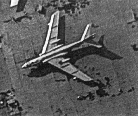
That is an excellent link for putting it into perspective. For the record, even after that link and reading way too much about this shit, I am still baffled that a plane can go missing. Once it is missing, I can see how it can be nearly impossible to find. But between satellites, radar, gps, cell phones, etc etc etc etc, I have a hard time imagining how can it simply go 'poof'. I just re-read your above posts and, with numerous other articles on the subject, I am starting to understand why it can go poof. But the concept that it can go poof is still beyond grasp, I guess. The idea that these supposedly omniscient technologies aren't so omniscient its a difficult one. Blame Hollywood or ignorance. It's still a weirdly troubling thing..
We do not do well with abstractions. You've seen planes. They are large. You've been in them, with more strangers than you have friends. You've seen oceans. They are large. You've been in them; they seem to go on forever. Our concept of "large plane" is pretty far off, though. Each wing on a 777 is the size of a tennis court, more or less. You've met people who have those in their back yards. our concept of "large ocean" is truly fucked. If you stand on the shoreline and stare out as far as you can see, how much ocean are you looking at? 1000 square miles? 100? Fourteen square miles. Also according to Wolfram Alpha, about 1/3rd the size of Disney World. So let's say you could see that downed plane. Let's say you're standing on the beach with binoculars looking out. You're trying to find, essentially, a tennis court in a piece of Disney World. It's about 1/1000th of the area you can see. ...that's if the plane crashed in sight of you. The world is a very big place, and we are very small on't. Even when hundreds of us pile into a can, we are still a flyspeck on the Epcot Center.
'm i sure doe but thou'rt righter, sure, inasmuch as I get into arguments with people for using "notoriety" to mean fame. Some people somewhere seem to have decided it's acceptable and now enough of them believe it.
That makes a hell of a lot of sense. Nasa can track every bit of debris in the upper atmosphere larger than a baseball and we actually lose track of a plane that's constantly broadcasting unencrypted time and position data? Especially with US naval resources (The 7th Fleet) not that far away. Edit to include that my geography professor held a discussion about this the other day, and when a classmate brought up the fact that the Malaysian, Australian or US governments might not be releasing information in the interest of national security, she was ridiculed. This bothers me because we know that our government has censored/classified/falsified important information in the past, but anyone who assumes that they would do so now is considered a loon. Just remember, Alex Jones was talking about the NSA reading everybody's emails/texts, listening to everyone's phone calls a long time ago and was called crazy. Turns out they are ACTUALLY DOING THAT AND HAVE BEEN FOR YEARS.
The point: Normal, non-insane, credentialed journalists made Alex Jones' point back when Alex Jones was in 2nd grade. It is, therefore: 1) Not Alex Jones' point. 2) Not a reason to not call Alex Jones crazy. Claiming that, for example, "the NSA is spying on us" and "NASA faked the moon landing" serves the purpose of deprecating the claim that "the NSA is spying on us" because the former is a well-documented fact and has been for decades while the other is a well-debunked paranoid delusion and has been for even longer. It certainly doesn't warrant caps lock - "stopped clock right twice a day" and all that. It's also not an ad hominem attack. It's an appeal to logic ("People think Alex Jones is crazy because he acts like a raving lunatic, not because he's pointed out NSA surveillance"). You would do our future discourse a service by striving not to conflate the two.