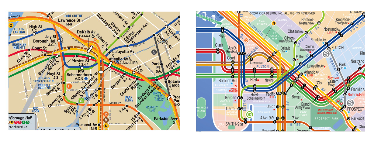
It looks like the Mongrel Maps are just the fingerprint smear tool from a simple photo editor. That doesn't make it a bad tool, but this interpretation of its results assumes that things I would love to know more about the MIT team's methods for assessing user processing of map. Did they watch a person's neural responses and compare them to eye movements? Did they simply assume the Mongrel is accurate? I lived in Boston for a dozen years and watched as the T map evolved. It has added hierarchy to the map, one that oddly reflects the racial realities of the city. Notice the Silver Line smudges out of existence on either Mongrel map. The article mentions this, but does not try to make any deeper conclusions. The Silver Line is a light gray, made to hide behind the 'superior' train-based lines. The Silver Line uses articulated buses with on-board fare collection along Washington Street to replace an elevated train line through black neighborhoods. back in the 1980s they moved the Orange Line, the former el, more than a mile to the west so that it serves Jamaica Plain instead of Roxbury. Hmmm... By the way, that circular route connecting the Washington Street (southern portion) of the Silver Line to the part that goes to Logan Airport (the eastern portion)? That's not real. They're separate systems (complete with separate power systems). We don't want the white folks to have an accident and wind up south of Mass Pike, now do we? Not with all their nice luggage on those special racks. Note that MIT is along the Red Line in Cambridge (between the Kendall and Central Square stops). Notice how the line is made obvious on the northwestern side of the route (short, simple). Now consider how the branch to Dorchester and Mattapan (black neighborhoods, the latter a former Jewish neighborhood) remains relatively clear but fractures much more on the branch to Quincy (a working class Irish suburb that has become an Asian neighborhood) and Braintree (the park and ride lot to the South Shore commuters and some Hispanic suburbs). Layers upon layers... I've stirred enough of my emotions by looking at the racism in the Boston T map. If we move back to the article's romance with Vignelli's 1972, we notice no picture of that map -- only the revisions used on the MTA web site. We see a lot of browns and yellows, a 1980 bag of peanut M&Ms with a modern blue candy. Even the red trunk (7th Ave IRT, aka 1/2/3) isn't the primary red found on the signs and in stations. The New Yorker article opens with a screen shot from the midtown Manhattan part of Vignetti's original map: Notice the cacaphony of colors? Notice the pink-puce-yellow for the Lexington IRT (4-5-6) instead of the modern green? Notice your mind drift to the opening credits of The Electric Company from PBS? Notice how you wince? Yeah, Central Park looks square and gray, as if it were what we now consider an unloaded image file. However that isn't the only reason people hated this map. They couldn't use it! Here is an amazing article about the hybrids that have evolved. This includes a great hybrid, the Kick Map, with a comparison for downtown Brooklyn: It's nice to think of a golden age of.. well, anything. Tea Baggers love to imagine a golden age where white men got their way but stayed in the closet. Some gay folks reminisce on the bath houses of the 1970s, when anonymous sex was guaranteed (and let's face it, who wouldn't love that for at least a couple weeks?). Each tunes out the problems that went with the time. Vignelli still feels he was short-changed by the 1979 revision. He has less standing than a 1980s band on Homestead or SST Records that still hasn't been paid for albums that maaagically appear in mint condition on eBay. A map is not purely about elegance: it has to serve. If a tourist cannot look at a map and say "oh, I'm here and I can do that to that to get where the other thing is" in a short time, then the map fails. A transit map is a service, a commercial product -- not an in-joke. I wonder whether Vignelli hates Google Maps for lack of colors. I hate their lack of boundary lines and the poor distinction between road qualities. .
. .
.